Time Machine in Drones?
Many of us have wondered what a landscape we see in a modern photograph might have looked like centuries ago. This question is especially intriguing when we know that the scenery has been radically transformed by human intervention over the past centuries. The Great Hungarian Plain (Alföld) is a perfect example: in the mid-19th century, river and water regulation projects turned what was once a partly marshy, swampy region into seemingly endless farmland. As recent years have brought recurring droughts—often linked to global warming—raising questions about the sustainability of this new land use, a new research result introduces a way to visualize historical conditions by generating “historical drone photos.”

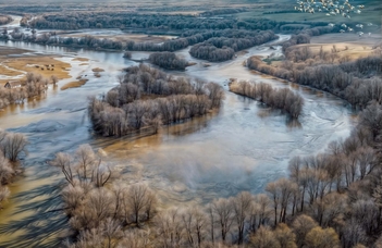
From drone photo to historical landscape: the Büs-ér in 2023 (top) and how might it have looked 250 years ago (bottom)
Researchers from the Institute of Geography and Earth Sciences—Gusztáv Jakab and Enikő Magyari from the Department of Environmental and Landscape Geography, Gábor Timár from the Department of Geophysics and Space Science, and Benedek Jakab from RAIZEN.Art—recently published a study in the journal Land titled “A Powerful Approach in Visualization: Creating Photorealistic Landscapes with AI.” The study’s lead author, Gusztáv Jakab, has spent years capturing drone footage of the increasingly arid landscapes and habitats of the Great Hungarian Plain. The goal of the present work is to estimate, using these drone images, what the landscape would have looked like from the same vantage point 200–250 years ago—if our drones had a “time machine” function.

A flood situation at Tisza-Körös confluence nowadays (top) and how could it have looked before water control works (bottom)
The article proposes a workflow using publicly available or low-cost artificial intelligence applications (primarily ChatGPT, Krea AI, Adobe Firefly, and Lightroom CC) to generate prompts that create such landscapes and outlines what the authors consider the optimal algorithm for this process. The study pays special attention to unique landscape elements visible in the input image that could not have existed in the past (e.g., roads, power lines), which should be excluded, as well as those that might be worth added in the result (e.g., characteristic animals or plant species). This raises the point that such visual reconstructions are most authentic when created by experts who understand the history of the landscape.

From a map of 1780s (left) to a historical view of the landscape (right)
A second key idea in the study is how to generate these landscapes when the input is not a modern drone photo, but a historical map from the period being examined. The first systematic mapping of Hungary was carried out during the reign of Joseph II, but earlier local engineering maps of smaller regions also exist. The article presents such an example. Unlike the drone-based approach, this method allows for fact-checking: by applying the algorithm used for old maps to a modern map as a starting point, the results can be compared to current drone images or, as demonstrated in the study, to Google Earth views.

Checking with modern cartography. The generated landscape (a) based on actual topographic map (b).
What may seem like just an “electronic toy” at first glance is, in fact, a powerful tool for visually and realistically presenting the pre-regulation landscape of the Great Hungarian Plain to a wide audience, in a way that is as verifiable as possible. This not only helps us better understand the original functioning of the landscape but also supports the acceptance of current strategies aimed primarily at water retention.
(Source: Institute of Geography and Earth Science)